
Sunday April 27th 2008 was a roller coaster ride of emotions for me. The convective forecast issued for the day was a promising one, in fact, it was the best so far this year. A moderate risk of widespread thunderstorms was on the cards for Ireland and UK. N. Ireland was very interesting indeed with ESTOFEX giving a level 1. Expert convective forecaster Tony Gilbert did a more detailed outlook and even focused on N. Ireland since I was pressing him for details. At 09.30 BST on Sunday morning the outlook was updated. Things looked even better since the night before with good wind shear so any storms which do form will have well separated updraughts and downdraughts. For the icing on the cake there was two convergence zone areas over N. Ireland. The first cut through the middle of Ulster passing over my location to the east of Lough Neagh in a vertical line and a second more enhanced region was located off the northern coast. In these two regions there was a higher chance of funnel clouds, tornadoes, and waterspouts over the Sea.
I spent the morning studying satellite images, radar images, sferics charts, and still nothing was happening. This time spent at the computer was a double edged sword because in one hand I needed to find out what was happening, however in the other I could be missing something spectacular outside. There comes a stage when you have to forget about computers and head outside for visual work under the real sky. There is no other way to get results. I decided to head out to my favourite location in the country and observe the sky. I don't like storms catching me off guard, my plan is always to get out there before they develop and watch them approach which is a good way to train your eye for spotting convective structures on the horizon and besides, I enjoy watching the sky change as the air mass provides new sights during the day. It was a stunner of a day, very warm with strong sunshine and calm, it could have been July not April. The convection began OK, there was plenty of cumulus towers growing which is always a good sign early in the day and I noticed that these towers displayed very obvious wind shear. After a period of time I knew something was wrong. The towers were small in size, very high based, and seemed to get softer with time until they formed groups of mid level altocumulus. The smaller number of towers remaining never seemed to get very high, a certain height was reached then they folded over so there was some kind of inversion or cap present which acted like a lid. None of these clouds glaciated into cumulonimbus cells. I was getting frustrated to say the least, I don't think I could put up with another one of those days when nothing happens. It was very relaxing and peaceful all the same. Sitting quietly on a hot rock I observed Rabbits playing around the fields then a beautiful Buzzard circled over me at low level which showed the presence of good thermals. It wasn't the only one, I casually looked up and seen a large glider sailing silently through the air taking full advantage of the air currents.
I had been out for several hours then decided to go back home again since nothing interesting was happening yet. I checked the usual suspects on the computer then enjoyed dinner. During the late afternoon a friend called over and together we drove up to Drumlamph forest outside Maghera for a walk. By now it was boiling hot with intense sunshine and it felt like one of those classic lazy Summer days when time stands still. I was actually starting to burn, at least I was getting an early start on my tan. The cumulus towers above me now were getting impressive and complimented by a partial Sun halo which made for a wonderful scene. At 17.30 we decided to head home. By now it was a mostly clear sky which made my heart sink and to top it all off the ground was beginning to cool which was not good. It felt hopeless for any action. However, I have learned from experience in astronomy that one must never give up, the tables can turn in your favor at any time.
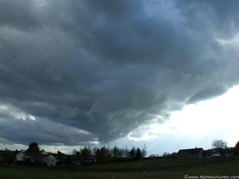
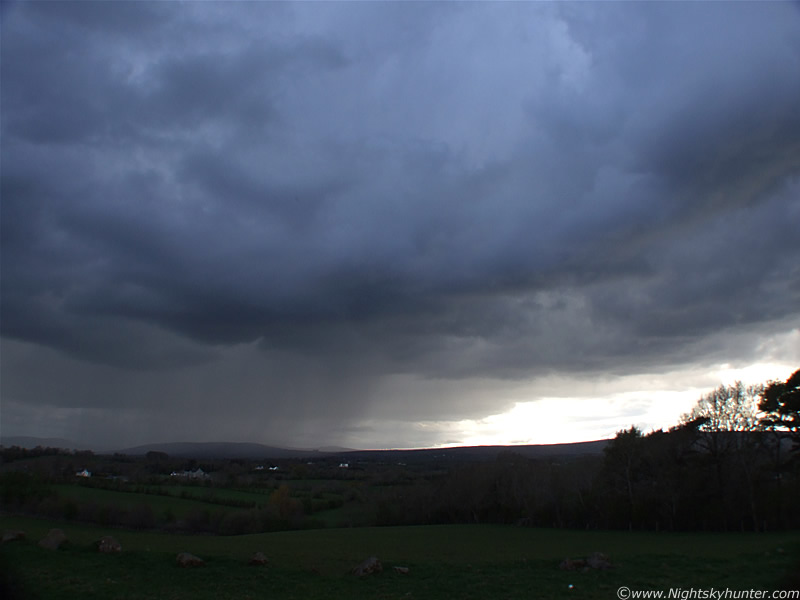
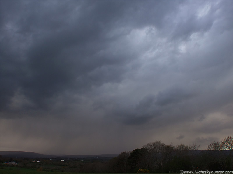
Back in my house my Sister was making fun of me and told me in no uncertain terms that there would be no thunderstorms today, ''I don't need a degree in meteorology to know that'' she said. I looked out of my bedroom window into the SE sky and said ''want to bet?''. In full view where several stunning crisp towers gleaming a proud white colour in the Sun light, and they were shooting upwards too at high speed!, whatever was capping this earlier had gone, it was obvious that convection was stirring. I grabbed the camera and walked a hundred metres up my estate for a better view. Those towers now looked like mushroom clouds from an atomic bomb so I climbed a hill which gave me a better view when I spotted something weird in the SW over the mountains. This was not like any typical class of convective structure and looked like a long low gathering of dark messy clouds which looked rather sinister. I couldn't quite place what I was seeing although it reminded me of some kind of strange out-flow, possibly a gust front. It was very slowly moving in my direction and I felt sure this was an approaching storm so I went back out to the country again for a good view.
During my trip along the Coleraine Road I lost sight of the storm for five minutes due to high hedgerows which blocked my view to the SW. When I walked into a clearing I glanced over and got a shock. That mess from earlier had rapidly organized itself into a very impressive storm structure. I walked up an embankment and began taking images using a fence post for support. The main updraught of this storm was like an inverted cone, I thought this could be a meso and for seconds I entertained the notion that this was some kind of supercell. With careful observation I could see that the cone was slowly rotating. What's more, I could see the free hanging cloud fragments wrapping around the cone as it rotated. At the tip was what looked like a small funnel, I wouldn't call it a lowering as the entire updraught was a lowering in itself. Look to the left of the 'funnel', you can see horizontal rows feeding into the area of rotation from L to R. You can imagine its motion just be looking at the image. This is facing SW, the Sun is illuminating the scene from the R low in the W which brought out the detail. These images are not darkened or super contrasted, this is exactly what it looked like with the naked eye. The sheep were wondering what I was doing, and so were the passengers in the cars which speed past me on the road.
 |
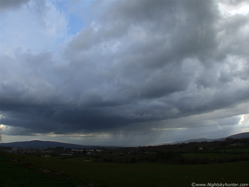
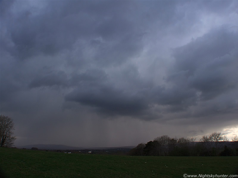
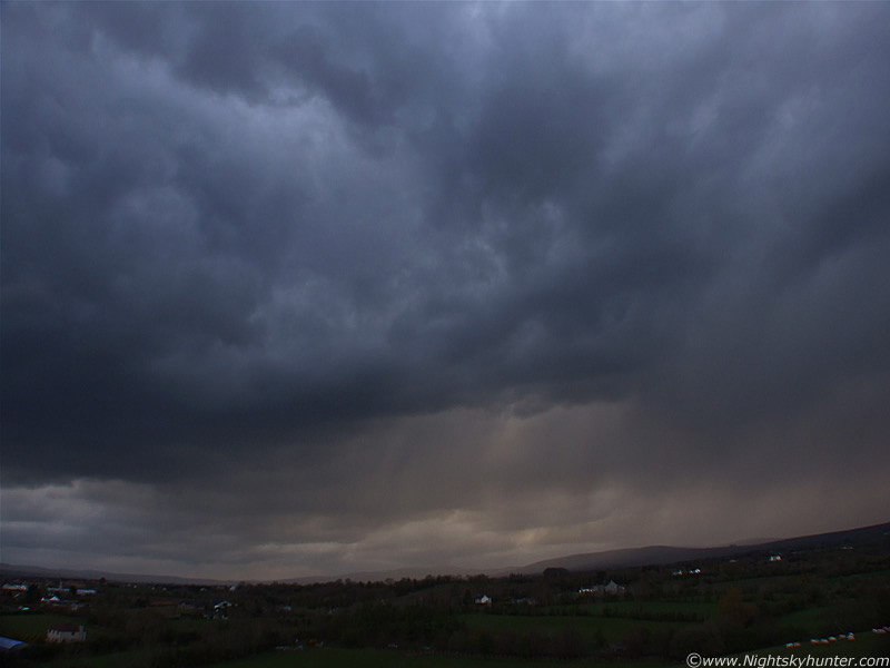
You can see the signs of rotation already. The storm has rotated in an anti-clockwise direction. I continued up the road and reached my destination. Facing S towards Slieve Gallion. This really organized itself into a massive storm system. At this stage I was sure a thunderstorm was brewing.
 |
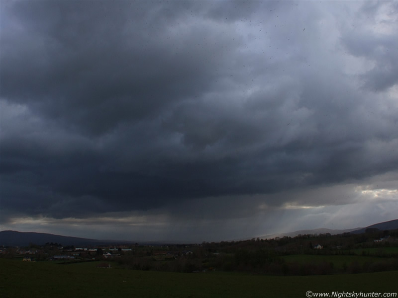
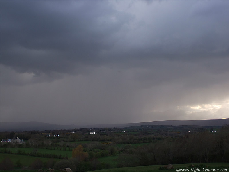
The view from my high vantage point. Looking SW at the approaching storm. That leading edge is the gust front.
 |
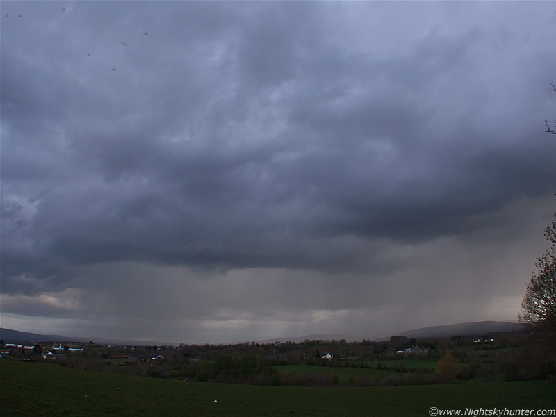
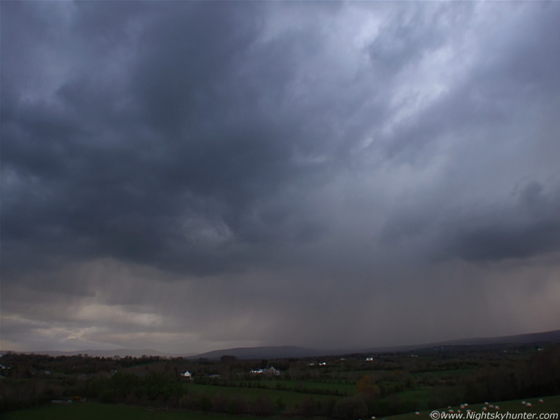
This was a VERY slow moving system so I was able to watch it grow at my leisure which was great. It was beginning to breath and build. A nice precip core has developed. Things were looking good. I thought I heard a few rumbling noises but I assumed it was the sound of the cars on the road below. I turned around behind me to check out another cell in the NE and when I looked back again a bright intra-cloud (I-C) flash of white lightning erupted from the leading edge of the cell, it looked like one of those fast animations of a supernova only the beams of light were longest on a horizontal plane. Note the blue glow on the edge of the cell to the upper part of the precip core, that's where the lightning came from. Seconds later I heard a loud and long-lived rumble of thunder. I was delighted and very excited. This was officially my second thunderstorm of the season and now my adrenaline was pumping. The black dots on the top of the image are midgets. The low Sun was now producing some gorgeous colours to the storm. The blue cell with pink precip curtain was fantastic. I was now taking regular images and video footage of the curtain for further action. That swarm of midgets became my new best buddies, the kind of buddy I don't want. Good job I have a shaved head or I would be itching now.
 |
Things had gone quiet again so I rested the camera. Suddenly a bright white coloured cloud to ground (C-G) bolt shot out from the storm and hit the mountain behind the tree line within the precip curtain to the L of centre followed by a loud and threatening rumble of thunder. That was an angry looking bolt and it made me feel very anxious.
 |
Storm getting more sinister in appearance. I love the N-S (R-L) split of detail on this storm. Chunky structure to the L, and complex to the right near the Sun.
 |
Closer with heavy precip now falling.
 |
Close up shot of the precip core over the Sperrins. It's the same area on the middle section of the above image.
My mobile phone began vibrating. I answered, it was Conor McDonald, he had been driving through the mountains when he also seen the lightning which was followed by an excited conversation about the action. The chat was cut short by another c-g bolt which shot out from the precip curtain and ahead of it from the middle of the above structure. The bolt was the best I have seen in a long time, it had an intense blue colour and came down to the ground at angle to the R. It was shaped like a branch of twisting forks. It was a dangerous brute and made contact with the ground in front of those houses in the distance. I'd say they had a great view of it. Another loud clap of thunder followed suit. These are wide angle so the storm seems further away than it really was. I would say that the bolt was approx one mile from me. It was a frightening sight, then the memories from 2006 came flooding back to my mind when my Sister and I nearly got killed by c-g's at night. I was now in danger and became concerned indeed. I decided to stick it out anyway, I was going to text my Sister to inform her I was out under fork lightning with my position so if things turned nasty from home they would be able to drive out and get me. Only thing was my phone was now out of credit, talk about a bad time. Lesson learned - always have credit on your phone when near t-storms. Conor text me to say he was heading to the Glen Shane Pass to watch the storm from there. A number of days later Conor managed to find out that this storm was very active at an earlier stage and produced a dangerous hail storm near Draperstown. The hail was larger than marbles, turned the roads white, and flooded the streets.
 |
Storm getting closer. I took many more still images and video clips in the hope of catching a strike. I found out very quickly that lightning strikes are like meteors, you aim your camera in one direction and the action takes place somewhere else. You move the camera to that location and another appears in your original area. Best thing to do in this situation is to stick to one area and try your best. Since lightning wasn't frequent I reckoned video footage would be the only way forward, I could always grab a still from it later. The sky wasn't dark enough for a time exposure. Capturing a daylight lightning strike is extremely difficult even with an active storm. It involves selecting the correct exposure, aperture priority, and a lot of luck. I certainly hope to catch more than one this season.
 |
Isn't mother nature amazing?. Just look at that amazing structure and those colours. I was enjoying every second of this. I could feel the first drops of rain from the storm hit my head and splash onto the LCD screen and I sensed danger. I would need to make a decision very quickly about where I was going to go.
 |
This was a fabulous contrasty and colourful scene. Now I'm glad the activity was late in the day otherwise this would have been a grey and unphotogenic scene. More on page 2.
PAGE 2 > |
Martin McKenna